Stay current with our travel food news coverage.
Why Winter Conditions Persist at Beartooth Pass
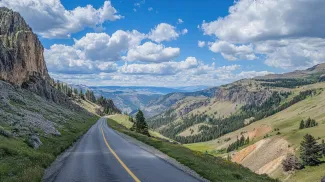
The Beartooth Highway is typically open from the Friday of Memorial Day weekend through mid-October, weather permitting, according to the National Park Service. In practice, that means about five months of access in a good year. The rest of the time, snow depth, avalanche risk, and icing keep the road shuttered. Even after the initial opening, conditions at Beartooth Pass remain genuinely alpine through much of the summer. Heavy snowfall and hazardous driving conditions have delayed openings in recent years, with the park warning in one recent announcement that the highway was scheduled to open on Friday, May 24, but remained closed through the weekend due to winter weather conditions, significant snowfall, and hazardous driving conditions. "After initial opening, weather causes occasional closures. Please check locally or at WY DOT and MT DOT before traveling," the National Park Service notes in its road status guidance for the Beartooth Highway. Montana DOT reinforces the point: "Unpredictable weather conditions at these high elevations do cause temporary closures throughout the summer." Social media posts from drivers who attempted the pass during marginal conditions illustrate the risks. One recent commenter noted getting stuck in Red Lodge for several hours as six inches of snow fell in two hours, with the road only reopening after a brief window of sun allowed plows to catch up.Jurisdictional Handoffs and Real-Time Advisories
The highway itself is maintained in segments. Montana DOT manages the stretch from Red Lodge up to the state line near the summit, and the National Park Service takes over the segment that descends through Wyoming and loops back into Montana toward Yellowstone's Northeast Entrance. That split means travelers need to monitor multiple sources for current conditions. Yellowstone advises checking Montana DOT and Wyoming DOT resources before departure, and in volatile periods those agency websites can show different status reports for different segments of U.S. 212. The elevation gain along the most dramatic stretch, from roughly 5,200 feet in Red Lodge to the 10,947-foot summit, happens in about 12 miles of switchbacks. That rapid climb means drivers can leave dry pavement and blue skies at the trailhead and encounter black ice, fog, and blowing snow before they reach the top. In late May and early June, forecasts have called for one to two feet of new snow with winds reaching 35 mph on the pass, conditions that make even four-wheel-drive travel dangerous and force closures that can last hours or days.The Booking Reality for Yellowstone-Bound Travelers
For travelers planning routes through Yellowstone's Northeast Entrance or building itineraries around the Beartooth Highway scenic drive, the message from the park and state agencies is simple: have a backup plan. The road may be officially open, but that status can flip overnight or even mid-morning as weather rolls through. I've worked in enough high-altitude environments, from the Canadian Arctic to Patagonian passes, to know that elevation trumps calendar every time. A June date doesn't immunize you from winter at 11,000 feet. The practical calculus here is straightforward. If the Beartooth Highway is a must-do on your Yellowstone itinerary, build slack into your schedule. Don't assume that because the road opened on schedule it will stay open during your window, and don't count on same-day reopenings if a storm does roll in. Local businesses in Red Lodge and Cooke City depend on this seasonal corridor for summer revenue, but they also understand that sudden closures are part of the deal. That local knowledge is worth tapping if you're on the ground; ask at gas stations, visitor centers, and lodges for current conditions and short-range forecasts, not just what the official highway status page showed when you left home. Check Montana and Wyoming DOT websites, Yellowstone's road status page, and National Weather Service high-elevation forecasts before you drive. If snow is in the forecast or if temperatures are forecast to drop into the 20s overnight, assume the possibility of icing and closures. Carry layers, food, water, and a full tank; if you do get caught in a closure, you may be sitting in Red Lodge or at a pullout for hours. This is not a road to approach with a tight connection or an inflexible schedule. The scenery is worth the effort, but only if you respect the altitude and the volatility that comes with it.More travel news
Ski Resorts Become Summer Golf Havens Across US
TRAVERSE CITY, Mich. - Boyne Golf spotlights 14 U.S. ski resorts doubling as summer golf destinations, from Maine to Montana, with courses carved into terrain that hosts skiers in winter.

Yellowstone's Freak June Snowstorm Shuts Roads
YELLOWSTONE NATIONAL PARK, Wyo. - Rare summer snow shuttered high-elevation roads in America's oldest national park just before the July 4 weekend, catching visitors off guard.

Yellowstone Tourons Risk Lives Approaching Wild Animals
YELLOWSTONE NATIONAL PARK, Wyo. - Tourists dangerously approaching bison and other wildlife have become so common that social media has coined a blunt term: tourons.

Discover Yellowstone Through Expert Eyes with Max Lowe
YELLOWSTONE NATIONAL PARK, Wyo. - Adventure filmmaker Max Lowe leads National Geographic Expeditions' education-focused trips through America's first national park, emphasizing photography, wildlife observation, and conservation storytelling.

About the Author

Jeff Colhoun
Jeff Colhoun is an acclaimed travel writer, photographer, and filmmaker, whose work is respected both in the United States and internationally.